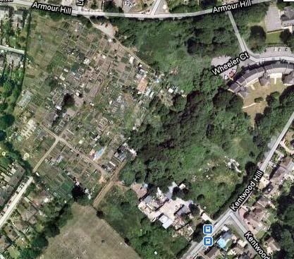
Theres a campaign to save the Tilehurst allotments from the builders. Website www.saveouropenspace.co.uk/
The land belongs to the the Tilehurst Poor’s Lands Charity. www.tilehurstallotments.co.uk/
Tilehurst Poor’s Land Charity dates from the early nineteenth-century, when the open fields, common meadows and common waste of Tilehurst were enclosed into private ownership under an Act of 1811. The fields were divided into strips, and each farmer had a number of strips in fields. The same crop was grown in each field in any particular year, and after the corn had been harvested, the livestock of all these farmers was grazed on the stubble to provide manure. The common meadows were by the Thames and the Holybrook. They too were grazed for part of the year in common, but grass for hay was held in strips, like the fields. The common waste was available for grazing and the gathering and cutting of fuel. These rights belonged to the owners and occupiers of certain properties, and most of the poor had no established rights on the common waste. However, rights to gather fuel had been allowed by custom. For some years, and this was seen as a way of reducing the rate for poor relief at no great cost.
When the common lands were enclosed,1/16 by value of the waste was allotted for the poor. This was at Kentwood Hill, Armour Hill and Polsted rd., including the allotment gardens and what is now the Victoria recreation Ground. This land still belongs to the Charity set up to manage it. There were further allotments of land at halls Rd and Chapel Hill. The land at Halls Rd and Chapel Hill were sold for residential development, and this provided the capital from which most of the Charity’s income comes. There are still six allotment gardens at Chapel Hill and some 80 on the other site.
Originally, the land was to be let and the rent used to buy fuel for the poor. This continued for many years, but gradually, with the decline of furze, wood and coal as fuel, grants were made to the poor for other purposes. The last coal tickets were issued in 1972. The area of benefit was originally the Ancient Parish of Tilehurst, which included Theale, Calcot and Holybrook. More recently, this area has been extended to include the Borough of Reading, as some of the Ancient Parish is now in the Borough. In practice, the area of benefit is to the west of the Reading West railway line.
The Charity has owned and let allotment gardens for over 80 years, as part of its letting of the land it owns. The allotments are seen as an investment, and there is no statutory duty on the Charity to provide them. The net annual income is usually around £750 a year, a small part of the Charity’s income.
The landlord owns another small allotment site off Chapel Hill, the Victoria Recreation Ground, the allotment site at Armour Hill/Polsted rd, and land (now uncultivated), called the ‘reserved land’. Most of the reserved land is bounded by Kentwood Hill; the rest is bounded by Armour Hill. This reserved land was let as allotments until 1998 when the tenancies on this land were not renewed. The Charity explained that they hoped to sell this land for housing, and the tenants were offered plots on the main remaining allotment site.
The proposals were controversial, and to date there has not been a successful planning application. There are many groups opposing development on the reserved land, the most prominent being Save Our Open Space/.
Currently Reading Council are reviewing the Local Plan. The new ‘Local Development Framework’ will contain details about the use of all land in the Borough. Some consultation about the future of the ‘reserved land’ has already occurred and more is anticipated. You can find out more by looking on the Reading Council web site page 83. Copied below.
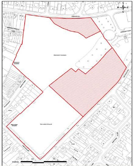
Site Address Land at Kentwood Hill and Armour Hill, Tilehurst
Customer/ RBC Reference/s SS28, 29, 52, 92
Size in ha 1.95
Current Use Former allotments (Tilehurst Poor’s Land Charity – ‘Reserved lands’) and builders yard
Description of Location Allotments and recreation ground immediately adjacent.
Residential surrounding site. Vacant builders yard buildings fronting Kentwood Hill.
Proposal/s 1) SS52 C3 housing for 60-70 units (hatched area); 2) SS28 & 29 (hatched area) and reserved lands to be protected under policy LEI 2 as a Major Areas of Open Space along with the whole area (whole area outlined above)
Constraints/ Issues Proposed development area adjacent to area covered by TPO 24/00 (group and individual trees). Should it be retained for open space and/or future allotment use? Potential contamination to be checked related to historic uses at builder’s yard. Allotments provide habitats for arrange of species. Part lowland mixed deciduous woodland (BAP habitat), potential for protected species. Covered by deeds trust. Proposal should include a desk-based archaeological assessment to clarify the impact of development and previous remains and ground clearance.
Site Reference: SA17

The consultation process on all LDF documents referred to above runs between 19th February and 2nd April 2010. Exhibitions on the consultation will be held at the following venues and times:
9 March 2010 South Reading Youth and Community Centre 9am to 1pm
9 March 2010 Tilehurst Library 2pm to 7pm
10 March 2010 South Reading Youth and Community Centre 2pm to 7pm
12 March 2010 Civic Centre, Committee Room 1, 2pm to 7pm
Responses can be made in writing to:
LDF Planning Team, Planning Department Civic Centre Reading, RG1 7AE
Tel: 0118 939 0286 Fax: 0118 939 0435
Or by E-mail to: ldf@reading.gov.uk


No comments:
Post a Comment